
Beautiful, colorful Bible land maps can bring stories alive as you read the Scriptures. You get to see the world through the eyes of those who were living there. Now we have numerous outstanding services on the internet which provide free, full color maps of every conceivable story, town and village mentioned in the Bible. Let me tell you about two of these online resources so that your Bible can come alive in a whole new way.
Bible Land Maps – Unique in Providing Maps Tracing People’s Journeys
 Check out Bible Land Maps. This site is unique because it has 132 maps broken down into 20 key periods of biblical history such as Before Abraham, The World of the Patriarchs, The Egyptian Experience and The Exodus, to name a few.
So as you read through each biblical period, you select which of the 20 periods you are reading about, and explore the maps which are listed under that period. One excellent thing these maps do is trace the journeys that people took. For example, Abraham as he traveled from Ur to Canaan, or the Israelites as they wandered in the wilderness, or Paul as he traveled on his missionary journeys. These maps provide wonderful visuals allowing you to “see” the walks they took, thus giving you a firmer feel for their stories and their lives.
Take a few minutes now and click through some of these maps to get a sense of how they can benefit you.
Bible Atlas – Unique in Connecting Google Maps to Bible Maps
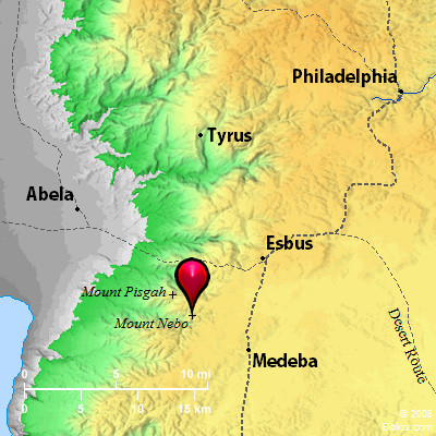 Now visit Bible Atlas. Here you have access to maps of essentially every location mentioned in the Bible, no matter how large or small the city may be. So, let’s say for instance you are reading Numbers 33:47. “They journeyed from Almon-diblathaim and camped in the mountains of Abarim, before Nebo.”
You may ask, “Where in the world is Abarim?” Well, when you click on Bible Atlas, you have a box that says “Atlas Search.” Great, so you type in the name of the mountains, “Abarim” and hit “enter.”
Sure enough you now see before you, Bible Map: Abarim (Mount Nebo). So you click on that and before your eyes is the “Area Map of Abarim” along with information about Abarim, and a listing of Bible verses which refer to Abarim. In addition, you find on the top of the page you have options to click on, a “regional map,” a “full page” map, and a “Google map.”
When you select Google map, a number of key related pictures are shown along the bottom of your screen. (If they do not appear, be sure that "Photos" is checked in the dropdown menu under "Traffic.") If you move your curser over these, a line connects them to their location on your Google map, and when you click on the picture you can see even more points of view.
The main Google map on your screen can of course be zoomed in for a closer look at any street or building, and as you zoom in and out, the pictures along the bottom of select locations on the map, change. So essentially you can take a modern day tour of any Bible city using these Google maps. Add this to the fact that you also have available the original biblical map along with passages from throughout Scripture which relate to that specific city or location. Absolutely awesome, and all these amazing resources are right at your fingertips. This is using technology for the glory of the Lord!
Try it. Let the Bible come alive!
Resources Which Take You Through the Bible
These online atlases are great companion resources for our Through the Bible modules, which you can enjoy as basic training curriculum, as part of our School of the Spirit Diploma Program, or as part of our CLU Degree Program.
Related Blogs:
Revelation-Based Learning


Add new comment